Travis Holland
Aug 9 is a big day for the @80days80stays around the world in a @HondaJet. Starting in Halifax, the route will take us up to Goose Bay, and then over to Narsarsuaq Greenland and then to Keflavik Iceland.
The ocean works a little differently then over land. Because there is no radar coverage across the oceans, and also no radar coverage in the entire southern half of Greenland, aircraft have to be separated by time and altitude rather than by radar observations. Instead of planes being 5 miles apart at the same altitude, they generally must be 120 miles apart in open oceanic airspace for planes not going the same direction.
For the hundreds of airliners that cross every day between 32,000 feet and 37,000 feet altitude, this means to them they might have to cross at an altitude a little lower or higher than they want, but that is the extent of their inconvenience.
The HondaJet (like most modern business jets and all light jets) wants to fly between 37,000 feet and 43,000 feet altitude, above the airline traffic. If forced to fly lower, jets consume around 50% more fuel per hour at 30,000 feet than at 40,000 feet.
Which is no problem in radar airspace. But a big problem when we want to descend into southern Greenland for fuel on our westbound trip. Because we have to be kept 120nm from any airplane at our altitude going the opposite direction, and because mid-day Greenland time coincides with the daily airline rush-hour traffic west-bound across the North Atlantic, it is practically impossible for ATC to descend you through the thicket of airplanes.
And the reason we are stopping in Greenland in the first place is because we don’t have enough fuel to hop over it, even at 43,000 feet where the best fuel economy is. This is the light jet paradox over the North Atlantic. You are stopping because you don’t have the range, and ATC realities mean you lose 1/3 of your range due to flying at such a low altitude.
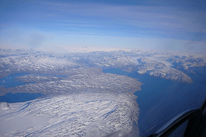
So, experience is that 29,000 feet is the most common altitude to be offered for a Narsarsuaq involved (S Greenland) North Atlantic Crossing. Which reduces the useful range of most light business jets to not too much further than the 670nm distance between Goose Bay and Narsarsuaq and Keflavik. I normally push as hard as I can for minimum 31,000 feet, but only with mixed success.
Departing Greenland, where the same problem occurs, I actually have Gander Oceanic on my phone’s speed dial and call them first and negotiate, before calling the control tower to request clearance.
Very careful planning is needed to be safe on this route. A few years back a Piaggio P-180 ran out of gas flying to their alternate after finding weather at Narsarsuaq to be below landing minimums. Compounding the risk is the high mountainous terrain all around the Narsarsuaq airport, including a chunk of granite rock rising to 1100′ directly on the 3 mile final for the airport.
N108GF crash near Kangerlussuaq — AIB Denmark
For our flight, we have an alternate route planned, via northern Greenland where there is one airport with radar, so desents/climbs from high to low altitude is possible. Kangerlussuaq (know as Sondrestrom or Sondy) is a few hundred miles out of the way, but if the weather is not fantastic at Narsarsuaq before we leave Goose Bay, we will accept the 30 minutes extra flying time and go via a northern route.
The southern route across the North Atlantic is particularly hazardous to light jets because of the unwritten ATC procedure to not clear aircraft stopping in Greenland to normal light jet altitudes. The risk can be mitigated, but easy to stumble into disaster if not mitigated effectively.
Fly safe everyone!